First modern atlas of the world returned to Cuba
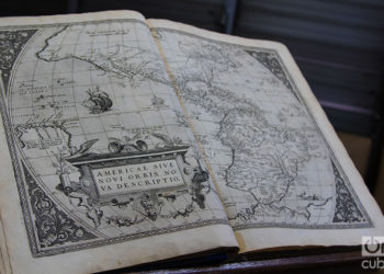
The first modern atlas, of which there are only three copies in the world, belongs to the collections of the National Library of Cuba (BNC). But it has not always remained there. In the 1990s an expert in valuable works stole it from the institution and sold it to the Boston Athenaeum. Now, two decades later, the copy has been returned to the island. The atlas published on May 20, 1570 in Belgium collects for the first time maps of America, the Antilles and Cuba. For Dr. Eduardo Torres Cuevas, outstanding historian and director of the National Library, one of the document’s greatest values is the location of Cuba in the Antillean, American and world geography. It is a collection of 53 maps with their corresponding texts made and engraved in copper plates that show how the world looked at that time. “America appears here very disfigured, which is logical if we take into account that it is made following the description of navigators. But at least thanks to Ortelius the island of Cuba is included in an atlas, although drawn much smaller than Santo Domingo, typical of 1570,” says Torres Cuevas. Its author, the erudite and geographer Abraham Ortelius,...


